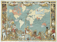
This session starts by looking at the information to be gleaned from a well-known 1886 map of the empire and ends with them writing an evaluative expert caption to accompany a textbook image which refers explicitly to the provenance.
Learning objectives
- Students understand how the Empire was perceived in Britain when at its height
- They are able to identify at least 8 key features of a map that cast light on the nature of the empire
- They can infer what the mapmaker was trying to say by what he included in the map
- They can evaluate the usefulness of the source to historians of the empire by explicit reference to its provenance
Step 1
In pairs students explore their own copy of the map (preferably enlarged to A3 and laminated for future use). They work their way round the map from ‘midnight’ moving clockwise, trying to find 10 significant

